Machu Picchu: The Lost City the Inca Never Forgot
Perched 7,970 feet in the Andes, Machu Picchu was abandoned within a century of being built. Its exact purpose, from royal estate to sacred observatory, is still debated.
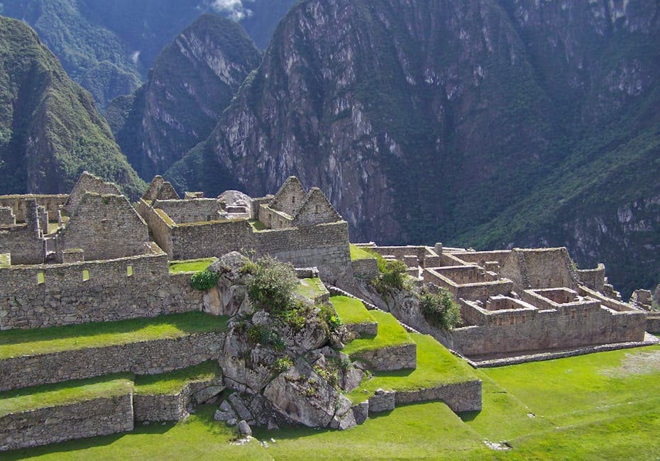
Nearly 8,000 feet above sea level, clinging to a narrow ridge between two peaks in the Peruvian Andes, sits a stone city that shouldn't exist. Machu Picchu was built in the mid-1400s by the Inca Empire at its height, a civilization that had no iron tools, no wheels, and no written language. Yet they constructed over 200 structures with walls so precisely fitted that you can't slide a credit card between the stones, engineered terraces that have survived 500 years of earthquakes, and a water system that still functions today.
Then, within roughly a century, they abandoned it. The Spanish conquistadors who dismantled the Inca Empire never found it. For nearly 400 years, the cloud forest slowly reclaimed its terraces and temples. And when American explorer Hiram Bingham publicized its existence in 1911, nobody could say with certainty what it had been for. That question, despite over a century of archaeological research, still isn't fully settled.
What You'll Learn
- •Who Built Machu Picchu and When?
- •Why Was It Built on Top of Fault Lines?
- •Was Machu Picchu a Royal Estate?
- •Was It an Astronomical Observatory?
- •Was It a Sacred Pilgrimage Site?
- •How Did the Inca Build Without Iron or Wheels?
- •Why Was Machu Picchu Abandoned?
- •The "Discovery" Controversy: Who Really Found It?
- •What We Still Don't Know
- •Frequently Asked Questions
Who Built Machu Picchu and When?
The current scholarly consensus attributes Machu Picchu to the Inca emperor Pachacuti (Pachacutec Inca Yupanqui), who ruled from approximately 1438 to 1472 CE. Pachacuti was the architect of Inca expansion, transforming what had been a regional kingdom centered around Cusco into the largest empire in pre-Columbian America, stretching 2,500 miles along the western spine of South America.
Radiocarbon dating of artifacts found at the site, conducted by researchers at Yale University, places initial construction around 1450 CE. The site was actively used for approximately 80 to 100 years before being abandoned around 1530 to 1540 CE, coinciding with the Spanish conquest and the collapse of the Inca state.
At its peak, Machu Picchu likely housed between 500 and 750 residents, including nobles, priests, artisans, and the yanaconas (servants) who maintained the estate. This was never a large city. It was something more exclusive: a planned, purpose-built settlement in one of the most dramatic landscapes on Earth.

Why Was It Built on Top of Fault Lines?
In 2019, geologist Rualdo Menegat of Brazil's Federal University of Rio Grande do Sul presented research at the Geological Society of America annual meeting that revealed something remarkable: Machu Picchu, along with several other major Inca sites, was deliberately built at the intersection of tectonic fault lines.
Using satellite imagery and detailed field mapping, Menegat showed that the ground beneath Machu Picchu is crisscrossed by fault zones running in multiple directions, primarily northeast-southwest and northwest-southeast. Far from being a hazard, these faults gave the Inca exactly what they needed.
Pre-fractured stone. Tectonic activity had already broken the bedrock into blocks of workable size. The Inca didn't need to quarry massive stones from distant locations; the faults provided a ready supply of building material right beneath the construction site.
Natural drainage. The fault zones created pathways for water to drain away from the foundations. Machu Picchu receives about 77 inches of rain per year, and without effective drainage, the terraces and buildings would have eroded centuries ago. The fractured bedrock acts as a natural drainage system, channeling rainwater downward and away from structures.
Site orientation. The faults influenced the layout of the city itself. Menegat found that many of Machu Picchu's buildings, stairways, and plazas are oriented along the underlying fault directions, suggesting the builders incorporated the geology into their urban planning.
This wasn't luck. The Inca built at least a dozen major sites on or near fault intersections, including Ollantaytambo and Pisac. They understood their landscape at a level that modern geologists are only now fully appreciating.
Was Machu Picchu a Royal Estate?
The most widely accepted theory, championed by archaeologist John Rowe and later supported by research from Yale's Richard Burger and Lucy Salazar, is that Machu Picchu was a royal estate belonging to Pachacuti.
The evidence for this interpretation includes:
A 16th-century legal document. A 1568 Spanish colonial petition references a place called "Picchu" as a royal estate belonging to the lineage of Pachacuti. This is the closest thing to a contemporary written record identifying the site's purpose.
The architecture. Machu Picchu's finest stonework, the kind with perfectly fitted blocks requiring no mortar, is concentrated in what appears to be a residential palace complex in the eastern sector. The quality of this stonework matches royal Inca construction in Cusco. Surrounding structures are built to a lower standard, consistent with quarters for attendants and workers.
Small population. With only 500 to 750 residents, Machu Picchu was too small to be a city, too elaborate to be a village, and too remote to be an administrative center. A seasonal retreat for the emperor and his court fits the evidence well.
Luxury goods. Excavations uncovered pottery, jewelry, and other artifacts indicating a high-status population with access to goods from across the empire. Ceramic analysis by Burger and Salazar showed styles from multiple regions, consistent with a cosmopolitan court.
If this theory is correct, Machu Picchu was essentially a vacation palace: a place where the emperor could retreat from Cusco, entertain guests, perform religious ceremonies, and enjoy the stunning landscape. This doesn't make it less impressive. It makes it more so, considering the engineering required to build a seasonal retreat on top of a mountain.

Was It an Astronomical Observatory?
Several features of Machu Picchu suggest it was designed with celestial observation in mind.
The Intihuatana Stone. This carved granite pillar (the name translates roughly to "hitching post of the sun") is aligned so that at the March and September equinoxes, the sun sits directly above the pillar at midday, casting virtually no shadow. The stone appears to have been used as a precise solar clock, marking the turning points of the agricultural year.
The Temple of the Sun. This semi-circular tower contains a window precisely aligned to catch the first rays of sunlight during the June solstice (winter solstice in the Southern Hemisphere). The light enters through the window and falls on a specific point on the central rock, which may have served as a ceremonial focal point.
The Intimachay Cave. This small cave below the Temple of the Sun has a window that admits sunlight only during the December solstice (summer solstice in the Southern Hemisphere). The precision of the alignment suggests deliberate engineering rather than coincidence.
These features don't necessarily make Machu Picchu an "observatory" in the modern sense. The Inca didn't separate astronomy from religion or agriculture; they were all part of a unified understanding of the cosmos. Tracking solstices and equinoxes was essential for planning planting and harvest cycles, which were central to Inca religious life. The astronomical alignments support the idea that Machu Picchu was a place of spiritual significance where the relationship between earth and sky was physically embodied in stone.
Was It a Sacred Pilgrimage Site?
Some researchers argue that Machu Picchu's location itself was sacred, independent of any practical function.
The site sits between the peaks of Machu Picchu ("Old Mountain") and Huayna Picchu ("Young Mountain"), with the Urubamba River curving around three sides far below. In Inca cosmology, mountains (apus) were powerful deities, and rivers were sacred pathways. The combination of dramatic peaks, rushing water, and the cloud forest that frequently envelops the site would have created a landscape charged with spiritual power.
The Inca Trail, the famous hiking route that leads to the site, passes through several smaller ruins and ceremonial gates before arriving at Machu Picchu through the Sun Gate (Intipunku). This sequential approach, building anticipation through a multi-day journey, mirrors pilgrimage routes in other traditions. The trail doesn't take the most efficient path to the site; it takes the most dramatic one.
Anthropologist Johan Reinhard argued in 1991 that Machu Picchu was a sacred landscape center, built at a nexus of geographical features (mountains, river, celestial alignments) that the Inca considered supernaturally significant. Under this interpretation, the site wasn't primarily a palace or an observatory. It was a place where the human and divine worlds intersected.
These theories aren't mutually exclusive. Machu Picchu was likely all of these things simultaneously: a royal estate, a ceremonial center, an astronomical alignment point, and a sacred landscape. The Inca didn't compartmentalize functions the way modern thinkers tend to.

How Did the Inca Build Without Iron or Wheels?
Machu Picchu's construction is remarkable not just for what the Inca achieved, but for what they achieved it with. Their toolkit included bronze and stone tools, wooden levers, fiber ropes, and human labor. No iron. No wheels. No draft animals capable of pulling heavy loads (llamas can carry about 75 pounds, not multi-ton stone blocks).
Stone fitting. The finest walls at Machu Picchu use ashlar masonry: individually shaped stones fitted together without mortar. Builders achieved this through a technique called "trial and error fitting," repeatedly placing a stone, marking where it didn't fit, removing it, chipping away material, and replacing it until the fit was perfect. The process was extraordinarily time-consuming but produced joints so tight that they've remained stable through centuries of earthquakes.
Earthquake resistance. The Inca developed several techniques to make their buildings survive seismic activity. Walls were built with a slight inward lean (about 3 to 5 degrees from vertical), making them naturally stable. Stones were cut with slightly rounded edges that allowed them to shift and resettle during earthquakes rather than cracking or toppling. Doorways and windows were trapezoidal (wider at the bottom), which distributes force more effectively than rectangular openings.
Water engineering. Machu Picchu's water system is a masterpiece of hydraulic engineering. A natural spring on the north slope feeds a canal that runs 2,457 feet to the city, where it cascades through a series of 16 stone fountains. The system was designed so that the emperor's fountain received water first (cleanest), with each subsequent fountain serving progressively lower-status residents. The entire system, including drainage channels that handle the site's enormous rainfall, still functions today.
Agricultural terraces. The terraces served multiple purposes: they created flat growing surfaces on steep slopes, prevented erosion, and managed water flow. Each terrace was built with layers of gravel, sand, and topsoil designed to maximize drainage while retaining moisture. Soil analysis has shown that some terraces contained soil imported from lower elevations, suggesting the Inca were practicing sophisticated agronomy.
Why Was Machu Picchu Abandoned?
Machu Picchu was occupied for less than a century before being abandoned around 1530 to 1540 CE. The timing strongly suggests a connection to the Spanish conquest, but the relationship isn't straightforward.
Francisco Pizarro's forces arrived in Peru in 1532 and captured Emperor Atahualpa. The subsequent collapse of the Inca state triggered civil wars, disease epidemics (smallpox reached Peru before the Spanish did, traveling along trade routes from Central America), and the destruction of the administrative systems that maintained sites like Machu Picchu.
But the Spanish never found Machu Picchu. There's no record of any European visiting the site during the colonial period. The city wasn't sacked or burned; it was simply abandoned. The by one account explanation is that without the Inca state to supply it, maintain its roads, and provide the laborers and artisans necessary for its upkeep, the site became unsustainable. A royal estate depends on a functioning empire. When the empire collapsed, the estate lost its reason to exist.
Disease may have played a direct role as well. Smallpox, measles, and other Old World diseases killed an estimated 50 to 90 percent of the indigenous population of the Americas. A small, isolated community like Machu Picchu's would have been particularly vulnerable.
The cloud forest quickly reclaimed the site. Within a few generations, jungle growth covered the terraces and walls, hiding the city from view but also protecting it from the looting and demolition that destroyed so many Inca sites in the valleys below.

The "Discovery" Controversy: Who Really Found It?
Hiram Bingham III, a Yale University historian, is widely credited with "discovering" Machu Picchu on July 24, 1911. The reality is more complicated.
Bingham was searching for Vilcabamba, the last capital of the Inca resistance against the Spanish. Guided by a local farmer named Melchor Arteaga, who knew the ruins well, Bingham climbed to the ridge and found terraces and walls still partially visible beneath the vegetation. A local family, the Recharte-Alvarez family, was actually living on and farming the terraces at the time.
Furthermore, a Peruvian farmer named Agustin Lizárraga had visited the site in 1902, nine years before Bingham, and carved his name and the date on one of the walls. Local residents in the Urubamba Valley knew about the ruins. What Bingham did was publicize the site to the international academic community and conduct the first systematic archaeological survey.
Bingham also removed thousands of artifacts and shipped them to Yale University, where they remained for nearly a century. Peru fought a long legal battle for their return, and Yale finally began repatriating the collection in 2011, exactly 100 years after Bingham's expedition.
The "discovery" narrative matters because it reveals how Western exploration has often claimed credit for knowledge that local communities already possessed. Machu Picchu wasn't lost. The people who lived nearby always knew it was there.
What We Still Don't Know
Despite being one of the most studied archaeological sites in the Americas, Machu Picchu still holds questions that researchers can't fully answer.
Its original name. "Machu Picchu" may not be what the Inca called it. A 2022 study by archaeologists Donato Amado Gonzales and Brian Bauer, examining colonial-era maps and documents, suggested the site was originally called Huayna Picchu after the adjacent peak, and that the name "Machu Picchu" was applied later, possibly in error by Bingham.
The complete population. We know roughly how many people lived there, but not exactly who they were. Skeletal analysis has shown a surprising diversity, with individuals from various ethnic backgrounds across the empire, but the social dynamics of the community remain unclear.
The full extent of the site. LiDAR surveys and ground-penetrating radar suggest there may be undiscovered structures and features hidden beneath the vegetation on surrounding slopes. The visible ruins may represent only a portion of the original settlement.
Why this specific location. The fault line theory explains the practical advantages, but it doesn't fully explain why the Inca chose this particular ridge among thousands of possible sites in the Andes. The sacred landscape theory offers a spiritual explanation, but that's harder to test archaeologically.
Machu Picchu remains a place where engineering genius, spiritual vision, and natural beauty converge in ways we can appreciate but don't entirely understand. Its builders left no written explanation of their intentions, and the stone, however precisely it's fitted, keeps its secrets.
For more ancient construction mysteries, explore Stonehenge, where builders moved enormous stones across Britain for reasons we still debate. The Pyramids of Giza present similar questions about how Bronze Age engineers achieved precision that challenges modern builders. And the Nazca Lines offer another South American mystery: giant drawings in the Peruvian desert visible only from the sky.
Frequently Asked Questions
How high is Machu Picchu?
Machu Picchu sits at an elevation of approximately 7,970 feet (2,430 meters) above sea level. The adjacent peak of Huayna Picchu rises to about 8,835 feet. For context, the site is lower than Cusco (11,152 feet), which means visitors who acclimatize in Cusco first actually descend to reach Machu Picchu, reducing altitude sickness risk.
Was Machu Picchu ever truly "lost"?
Not to local people. Farmers in the Urubamba Valley knew about the ruins and some even cultivated the terraces. Peruvian farmer Agustin Lizárraga visited in 1902 and carved his name on the walls. What Hiram Bingham did in 1911 was bring the site to international attention and conduct the first archaeological documentation. The "lost city" narrative, while romantic, overstates how unknown the site actually was.
How did they get water to the top of a mountain?
Machu Picchu's water comes from a natural spring on the northern slope of the mountain, fed by rainfall collected in the geological formations above. The Inca built a stone canal 2,457 feet long to channel this water to the city, where it flowed through 16 carved stone fountains arranged in a descending sequence. The system is gravity-fed and required no pumps or mechanical devices. It still works today.
Can you still visit Machu Picchu?
Yes, but access is regulated. Peru limits daily visitors (currently around 4,044 per day in timed entry slots) to protect the site. Visitors must purchase tickets in advance and enter during a specific time window. The classic Inca Trail hike requires permits booked months ahead. The site is a UNESCO World Heritage Site and one of the New Seven Wonders of the World.
Why didn't the Spanish find Machu Picchu?
Machu Picchu's remote mountain-ridge location, accessible only by narrow trails through dense cloud forest, made it virtually invisible from the valley below. The Inca road system that connected it to Cusco fell into disrepair after the conquest, and the jungle quickly reclaimed the paths and terraces. The Spanish focused their attention on the more accessible and wealthy cities in the valleys, and local people apparently didn't reveal the site's existence to the colonizers.
Further Reading
This article contains affiliate links. If you buy through them we may earn a small commission at no extra cost to you.
Want to explore more mysteries?
We've got plenty more rabbit holes to go down.